
The Pemi Loop
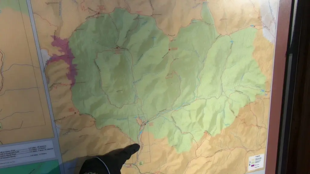
The Pemi Loop is a rugged 31 mile loop connecting eight different New Hampshire 4,000 foot mountains in the Pemigewasset Wilderness. Located in the White Mountains, the trail is a notoriously technical and scenic single/multi-day trek and is arguably the most popular Fastest Known Times (FKT) in New England (more info here).
With almost 10,000 feet of elevation gain on the Pemi Loop, the first few miles begin on the Lincoln Woods Rail Trail. By climbing a few thousand feet to the Franconia Ridge, the path traverses Mt. Flume, Liberty, Lincoln and Lafayette. The trail continues over Mount Garfield to the Galehead Hut at mile 16. Often described as a death march, the 0.8 mile ascent up South Twin Mountain is the beginning of another ridge line that traverses Mount Bond and the Bondcliffs. Following the Bondcliffs, the trail drops a few thousand feet back to the rail trail with five flat miles leading back to the parking lot. Seems easy, right?
Footing is generally rocky, rooty and featuring occasional scrambles. The trail is designed to be hiked, not ran. Trail conditions are sometimes muddy and can be flooded following rain. I paid attention to conventional wisdom and did my Pemi Loop after an entire night of rain and snow, followed by freeze-thaw conditions. Go me!
Prepping to Run the Pemi Loop
I hope you are ready an adventure in New Hampshire’s White Mountains! The day is action packed, and I’m about to have a lot of fun. Often, weather intimidates me to stay indoors. Not this time.
The Pemi Loop has been in the back of my mind for a while. I’ve hiked numerous sections of this loop. I have climbed 34 of my 48 New Hampshire 4,000+ foot mountains. Katie, my wife, is leaving on a weekend getaway to South Carolina, so I have the weekend free. Ever since I started exploring the White Mountains in 2015, I’ve been itching to do this journey in one go. Ten FKTs have been set in the past ten years, most recently by my friend Patrick Caron in a time of 5:45:12. The trail is more like a European sky race than it is a mountain race or ultramarathon.
It is Friday night in my cozy Boston apartment. I check the weather religiously. When I made my plans to head north last Tuesday, weather looked chilly, but pleasant. High 20’s on the ridge line and mid 40’s in the valley – mostly sunny. However, a storm had decided to roll in the night before my Saturday attempt. My iPhone shows rain cloud emojis for hours, so the Pemi is getting dumped with rain and possibly some snow overnight. The rain will have a chance to freeze. Great.
I pack my bag for the journey. With two liters of water, it totals 8 pounds. My Columbia bag holds my Columbia OutDry jacket, tights, water bladder, GoPro 7, cell phone, keys, buff, YakTrax, four 160 Maurten drink mix packets and two Maurten 100 gels. I’m wearing shorts, t-shirt, hat and arm sleeves with my Trans Alp FKT II shoes. I’ve never worn these shoes in extreme icy conditions, but these are my go-to shoes in serious mountain races like UTMB. I hope they will hold up.
I wake up Saturday and weather reports confirm the prediction, everything is soaked and/or freezing on the Pemi Loop. I hop in my car in Boston for the two hour drive to the Lincoln Woods parking lot. I jam out to Red Hot Chili Peppers and Lizzo on the way up. Rage Against the Machine comes on the playlist, I’m excited. Patrick Caron’s record may or may not be out of reach in these conditions, but I’m going to give my all.
Up the First Climb
What does the start-line of a race feel like? Friends and family are cheering. The sun is rising majestically above the trees. Months of preparation have taken you to this specific moment. The body feels loose and limber, ready to take it all on.
Yeah, that’s not how it goes with FKTs, at least not this one. I park my Honda Fit in a mostly empty parking lot in the middle of the woods. Exiting the car, I stretch out my legs and take a short walk. I am alone. No one will even notice if I just go home and call it a day. After walking for a few minutes, I took a selfie. I guess I wanted to remember what the dead foliage looked like before I set off.
I checked my phone for an important note on fastestknowntimes.com:
NOTE: The Pemi Loop has a Strava Segment. But, the Segment starts & ends on the north side of the bridge over the East Branch Pemigewasset River. The FKT is car-to-car, so starting and ending at the parking lot. It’s not a huge difference (about 500′ total), but for such a competitive FKT it is important to have consistency.
So, I set my new GPS watch and pick an ambiguous spot that might constitute the ‘end of the parking lot.’
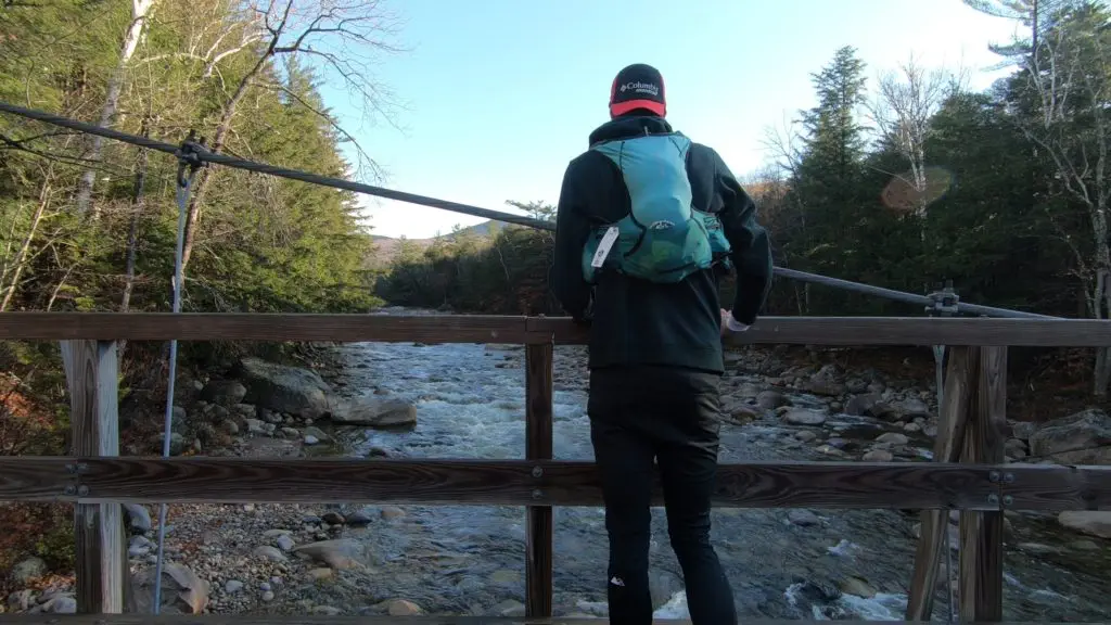
I go out strong. Going to clockwise direction, you tackle the hardest part of the Pemi first. The first 1.5 miles of old railroad bed is a little jarring, however I make good time before turning onto the Osseo Trail. Then, I climb.
Let me say that again. Then, I climb.
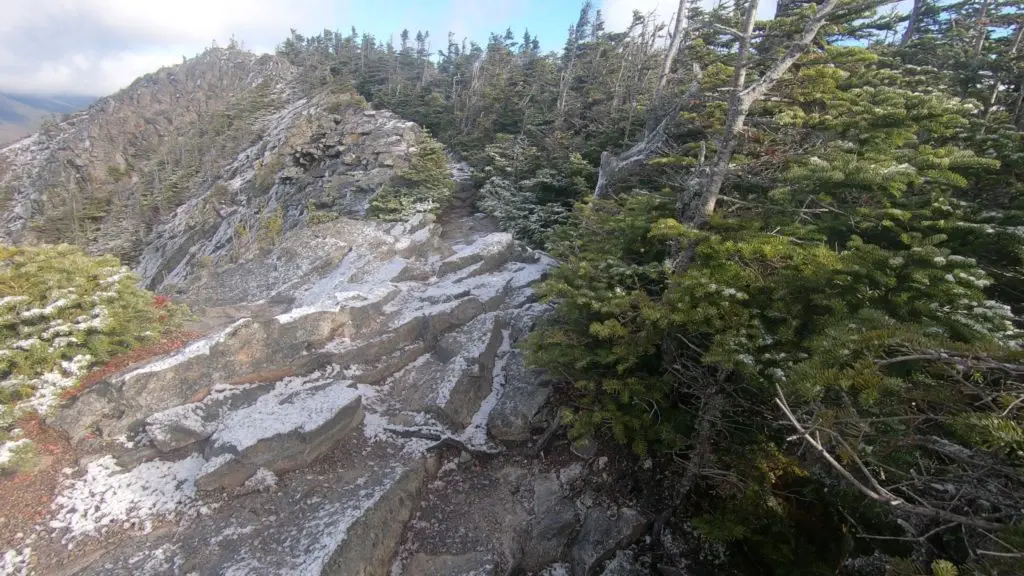
Usually, my preferred morning kick starter is a nice chai latte. Today, I woke up to 3,000ft of elevation off to the face. Despite knowing the elevation profile, I’m not ready for that. Icy ladders and some slippage on rock slabs don’t boost my morale. Once atop Mount Flume, I admire my surroundings. Views look nice, but a foreboding cloud hangs above the peaks of the iconic Franconia Ridge.
High Winds on the Ridge
Footing is sketchy. My body is now cooling down. I tug at my thin arm sleeves for warmth. A couple watches from afar, ‘Damn, bro. Stay warm out there!’ he yells. Don’t worry bro, I will.
After climbing almost 4,000ft in the first two peaks, I’m now boulder jumping on exposed slab. Did I mention the ice? My Columbia shoes make good traction out of what is underneath me, but I’m moving so slow. Descending from Liberty, the trail quickly takes me below tree line. Now I’m in the ice/mud kingdom. Rocks and the occasional branch are the stepping stones that keep my feet dry. You might imagine how smooth I am running at this point. If you can’t, it is about 17 min/mile pace.
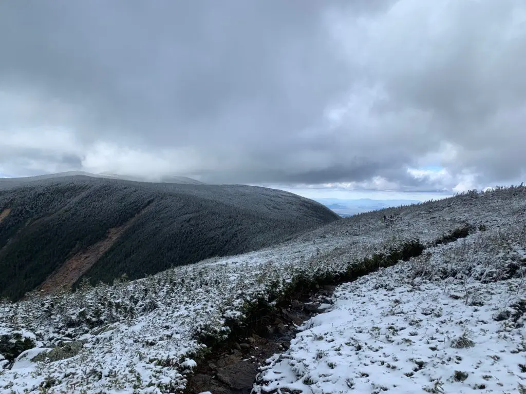
Up next is a four mile exposed section along Franconia Ridge. I circumnavigate a blowdown on the trail. The entire section is socked in with fog. I don’t get any views. At this point my heart sinks. All hopes of breaking the FKT on an important trail to me go out the window. What do you do when the mountain breaks you? I’m now running up a snow covered mountain top that feels more like the Alps than the Whites. What happens when you won’t achieve your goal, but you have miles of tough trail ahead of you? I am in over my head. My body pushes forward irregardless.
Thoughts creep into my mind. Am I wasting my time? My friends are having lukecold pre-Halloween beers, and I am in sipping on Maurten and trying to not split my head open on ice. My wife is on a mother-daughter weekend getaway to Charleston, and I am wearing arm-sleeves and a t-shirt in 28 degree fog and whipping winds. I keep climbing.
An audible ‘Joe’ is whispered in the winds. Wait a second, am I hearing things? “Is that Stringbean?!” a hiker who I had just passed yells at me.
Confused, I asked who it was. “Its Chicken Bone. We met on the AT in 2017 in the Bigelows!” the figure responds.
Sure enough, I recall the trail name. We’d had a short trail side chat and both hiked the AT in the same year. My body is freezing, so we give each other a quick fist bump, and I carry on.
Crossing paths with Chicken Bone take me out of my head. Sometimes, a brief human connection renews you with purpose. As I cross over Lafayette at 5,249ft and 10 miles into my journey, the composition of the ground changes. Before, I was running on half of an inch to an inch of snow with sporadic ice in an alpine zone. Upon summiting Mount Lafayette, the main hiker trail heads east off the ridge, but the Pemi Loop continues north. I am now on the windward side of the mountain. That means that the wind is hitting me in the face and that the snow is accumulating on a trail that no one hikes on.
Now I am downhill jogging through a foot to a foot and a half of snow. There are buried rocks and trail markers, so I watch my footing and find myself off trail a few times. I hit a somewhat steep downhill and my ankle twists. Nothing pops or breaks, but I can feel my tendons and ligaments being pulled past their comfort zone. Damn.
Descending on more snow and ice, I gingerly limp downward. Due to the cold temperatures, my left eyelash has started freezing at the ends. Talk about frosted tips, am I right?
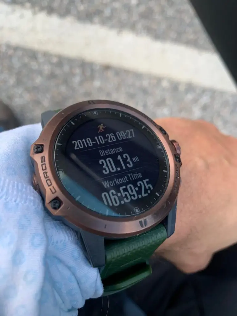
Finally, I descend beneath treeline thankful to get off the blustery bluff. My body took a beating, but I made it through the hardest 12 miles. At this point, I’ve climbed over 6,000ft of the 9,700ft of elevation that my COROS Vertix watch would read upon my return to the trail head.
No Water at Galehead
Now I’m starting to get Appalachian Trail flashbacks. Before this point, the trail has had a distinct winter wonderland feeling. Back in 2017 when I set the self supported AT Fastest Known Time, I’d traversed 10 miles of this same section. In 2017, I was at an all-time low. I’d turned the wrong way off of South Twin Mountain and added an extra 6 miles and 2,500ft of elevation to my day. Now I was getting back to familiar territory. I wouldn’t make that mistake again.
After a rocky, and still icy, ascend of Mount Garfield, the trail drops down a waterfall on the other-side. About 200 feet in length, the trail becomes an array of misplaced boulders and water flows. I’ve always been very fond of this little section, you will be hard pressed to find anything like it.
Coming off Mount Garfield, you hit and undulating and laborious trail. Although you hit mostly flat trail for a significant trail, the windy, flooded trail and wet, slanted granite slabs make it impossible to make good time. I’m still going at a steady 17 minute mile.
At this point, my water bladder is almost empty. At about 15 miles in, I’d have almost all of my Maurten mix drink, which is about 2L of water and 640 calories. I’d also had a 100 calorie gel bringing my total to 740 calories. Nearing the four hour mark, I haven’t had as many calories as I’d like, but at least the Galehead hut will be able to give me a second to warm up, collect myself, and load up on water.
I’m almost at the hut. In 2017, I’d bought two baked brownies from the AMC Hut Croo who attends the White Mountain Huts and enjoyed myself. This visit needs to be brief. As I come upon the structure, a girl is doing a hand stand in front of the scenic Galehead Hut view. Why are hikers so weird? I can only assume that photo is somewhere out on Instagram by now.
Oddly, the area around the hut is littered with hikers. The though ‘Why aren’t they inside?’ crosses my mind just as the thought ‘Oh my god, the hut is closed!’ slaps me across the faces. “Wait, the hut is closed?” I ask a nearby hiker who is taking his time enjoying epic wilderness.
“Yep,” He grunts. I think I confused him, because I was confused myself.
In that moment, I didn’t really know what to do. As you probably guessed by the title of this section, there is no water. And I need water to consume more calories. My head fogs as I need calories to climb the 3,000ft and 14 miles remaining. There’s snow and ice everywhere. I wish I had a picture of my reaction. There was no one to argue with and nothing to complain about. I’m a master of my own destiny. Time to go up the most miserable South Twin Ascent.
Descent into Freedom
Patrick Caron has ascended the 8/10th of a mile climb with 1,200ft of elevation gain with mile splits of 18:30 and 21:07. Scheming to run the Pemi Loop in my comfy apartment in Boston, these two numbers stuck out. How did he do it so fast? The climb is like a Stairmaster that is made of rocks. The trail climbs straight up. Everyone complains about it. It sucks. However, Patrick’s splits gave me hope that it wasn’t that bad.
Turns out, the South Twin climb is that bad. My splits on this section were 24:10 and 20:38. I was huffing and puffing. Sweat dripped off my face, melting the droplets of snow that it landed on. In fact, I don’t really want to recount that experience, because the climb was not enjoyable.
By the time I made to the top, I was ready to be done. However, the human capacity to endure is fickle. Upon reaching the top, the trail rewarded me with sweeping views of frosted tree tops and ominous clouds loitering over Franconia Ridge. Spectacular. My GoPro was fully dead at this point, so all I could do was admire the beauty with my eyes.
Coming off South Twin, my mojo returns. Stringbean is back! I cackle to myself as I hopped from icy rock to icy rock. I’ve conquered the biggest climbs, now I’m basking in the glory of my favorite mountains. Who else is dumb enough to be try to do a Pemi Loop this time of year? All those poor folks sipping on beers, idly passing the time. If only they knew what they are missing.
Despite the low rations, I’m still in high spirits. Coming up on the second to last 4,000 footer, Mount Bond, a trail spur wanders off to the right. The trail is a 1 mile detour that leads to another 4,000, West Bond. The add-on isn’t necessary, but for those of you trying to knock off your 4,000 footers, West Bond is nightmare to return to. Do I add on another twenty minutes to my adventure, or should I play it safe under the conditions of limited calories, water, and fading light.
The choice is obvious.
As I stand atop West Bond, my lungs fill with crisp mountain air. The Pemi Loop is truly a wonderful contraption. Seven 4,000 footers create a bowl of hardened New Hampshire ridge line. Mount Lafayette looms under a swirl of clouds. Two boulder fields lie beneath Galehead Mountain, leaving earthy scars to contrast dense forest.
Upon returning from West Bond, I only have Bondcliff left. By now, my grieving stage is over. In these conditions, I was never going to set an FKT. Not achieving my goal isn’t ruining my fun. With a smile and a groan, I take my last steps over Bondcliff. My legs are sore, my throat is dry, but my body can go to hell. This is living.
With 3,000ft of elevation to lose and only 8 miles to go, I let my stride open up. I can feel my snow-conscious, dainty steps become confident. My legs feel strong. I throw my body at the trail, and it responds like a well-oiled machine. My mind enters a meditative state, I only focus on the repeated falling of my feet on stone and leaf.
The trail zigzags across a few streams and lands back on the Lincoln Woods rail trail where my journey began. I haven’t seen flat, stable terrain since six hours ago, and I cruise the last five miles, running sub 6:30 in the last two miles to finish at the parking lot with a time of 6:59:25.

Total Distance on my Coros Elevation on my Coros 
My beautiful feet


Post Run Reflections
What a great way to spend a Saturday. Despite finishing on fumes, I had a blast. I am proud that tough conditions didn’t take me out from even attempting the trail. Challenges come up in life, and you can either choose to quit or overcome. If I didn’t do the Pemi Loop this weekend, when would I? In the Spring? Summer? A year from now? Two years from now?
I managed to make the seven hour trek on two liters of water and 740 calories. My Columbia shoes were fantastic, I’m still surprised that I didn’t need to use any kind of microspike. I stopped by the Black Mountain Burger Co and ran into someone who follows me on Instagram. Sounds weird, right? It was actually pretty natural, Megan and Guy were also enjoying a burger and we talked about 4,000 footers, life in and around Boston and running.
I hope you enjoyed the recount of my wild day on the Pemi. If you want to continue following on my journeys, you can find me on Instagram (@TheString.Bean), Facebook. I also have a fair amount of video from my GoPro, be on the look out.
Please share and comment below!
[subscribe]
[disclosure]


That is just an absurdly fast time!!! I just did a solo hike of the Pemi Loop this past Friday and it took me almost 19 hours!!! lol Great job!
Thank you! Would’ve liked to been a little more toasty but the snow made that probable. You should revisit the Pemi in a year! It is one of the best running routes in NE and I bet you’ll surprise yourself if you are trying to push it!
Un-Freakin-Believable… super impressive in that time. Best hikers i I know do it in 13 or 14 hours plus, usually closer to 16 hours and that’s in ideal weather…
Thanks Steve! I knew I was in a bit of trouble going up Liberty and experiencing ice on the steps… Then I got up high enough and hit the real snow. But it made for one great adventure!